

You can find on this page the Japan region map to print and to download in PDF. The Japan political map presents states, regions, provinces and surrounding areas of Japan in Asia.
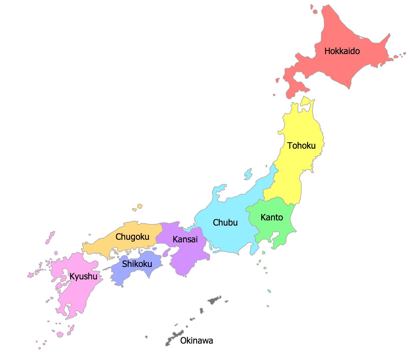
The Japan regions map shows surrounding areas and provinces of Japan. This administrative map of Japan will allow you to know regions of Japan in Asia. The Japan regions map is downloadable in PDF, printable and free.
The regions of Japan are not official administrative units, but have been traditionally used as the regional division of Japan in a number of contexts. For instance, maps and geography textbooks divide Japan into the eight regions, weather reports usually give the weather by region, and many businesses and institutions use their home region as part of their name as you can see in Japan regions map (Kinki Nippon Railway, Chūgoku Bank, Tōhoku University, etc.).
From north to south, the traditional regions as its shown in Japan regions map are: Hokkaidō (the island of Hokkaidō and nearby islands, population: 5,507,456), Tōhoku region (northern Honshū, population: 9,335,088), Kantō region (eastern Honshū, population: 42,607,376), Nanpō Islands: part of Tokyo Metropolis, Chūbu region (central Honshū, including Mt. Fuji, population: 21,714,995), sometimes divided into: Hokuriku region (northwestern Chūbu, largest city: Kanazawa), Kōshin'etsu region (northeastern Chūbu), Tōkai region (southern Chūbu, largest city: Nagoya), Kansai or Kinki region (west-central Honshū, population: 22,755,030), Chūgoku region (western Honshū, population: 7,561,899), Shikoku (island, population: 3,977,205), Kyūshū (island, population: 14,596,977) which includes: Ryukyu Islands (Nansei-shotō), Satsunan Islands: part of Kagoshima Prefecture, Ryukyu-shotō and Daitō Islands: Okinawa.
Each region has its own dialect, customs, and unique traditional culture as its mentioned in Japan regions map. For example, the Kanto region, which includes Tokyo, and the Kansai region, which includes Osaka, offer striking contrasts in everything from the taste of food to the style of traditional performing arts, and people have fun comparing them.

The Japan political map shows regions and provinces of Japan. This administrative map of Japan will allow you to show regions, administrative borders and cities of Japan in Asia. The Japan political map is downloadable in PDF, printable and free.
The politics of Japan is conducted in a framework of a parliamentary representative democratic monarchy, where Prime Minister of Japan is the head of government. Japanese politics uses a multi-party system as you can see in Japan political map. Executive power is exercised by the government. Legislative power is vested in the Diet, with the House of Representatives and the House of Councillors. The judicial system of Japan is an independent entity. In academic studies, Japan is generally considered a constitutional monarchy with a system of civil law.
The Imperial House of Japan is headed by the Emperor of Japan. The Constitution of Japan defines the emperor to be "the symbol of the state and of the unity of the people." He performs ceremonial duties and holds no real power, not even emergency reserve powers. Political power as its mentioned in Japan political map is held mainly by the Prime Minister and other elected members of the Diet. Sovereignty is vested in the Japanese people by the constitution. Though his official status is disputed, on diplomatic occasions the emperor tends to behave as the head of state (with widespread public support).
For other political parties see Japan political map. An overview on elections and election results is included in Elections in Japan. The LDP has been the dominant party for most of the post-war period since 1955, and is composed of several factions. Political parties had begun to revive almost immediately after the occupation began. Left-wing organizations, such as the Japan Socialist Party and the Japanese Communist Party, quickly reestablished themselves, as did various conservative parties.
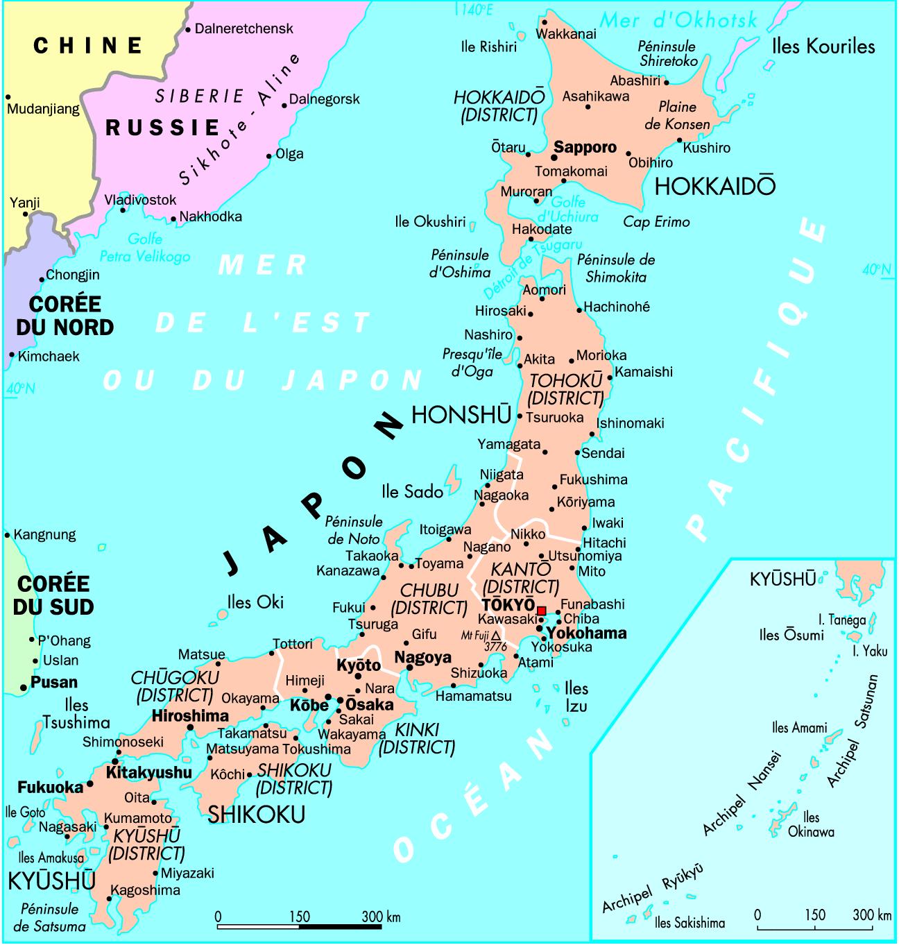
The Japan states map shows all departments and regions of Japan. States map of Japan will allow you to know areas and cities of Japan in Japan. The Japan states map is downloadable in PDF, printable and free.
There are no “states” or “provinces” in Japan, because Japan is not a federal system but a unitary state with a two-tier local government system as youcan see in Japan states map. “Shi” (city), “Machi” or “Cho” (town), and “Mura” or “Son” (village) are the basic municipalities that offer basic administrative services to residents.
There are 47 prefectures or states in Japan as its shown in Japan states map: 1 “to” (Tokyo-to), 1 “do” (Hokkai-do), 2 “fu” (Osaka-fu and Kyoto-fu), and 43 “ken.” “Do,” “Fu,” and “Ken” have the same functions. The nominal differences exist for historical reasons, but a “to” has special function. Because Tokyo is the capital of Japan and has a large population in a small area, the Tokyo Prefectural (Metropolitan) Government has the same authority as that exercised by cities in other prefectures. As a result, there are no cities, towns, or villages in within the Tokyo downtown district, but there are 23 “Ku” (wards) that have limited administrative authorities.
The below map shows the pre-Meiji states of Japan. Utagawa Hiroshige III (1842–1894) in his 1877 series Dai Nippon Bussan Zue (Products of Japan) used these pre-Meiji names to identify the states whose industrial activities he depicts. Though the majority of Japan former states were converted into prefectures by the Meiji government between 1870 and 1876, it was not unusual for these "ancient" names to continue to be used.